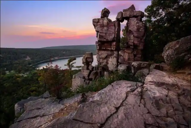
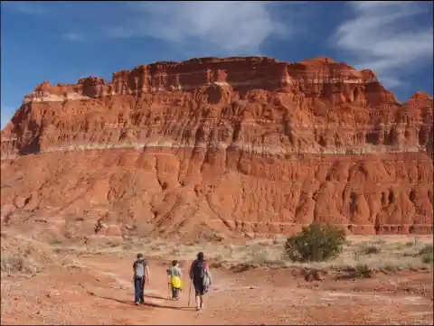
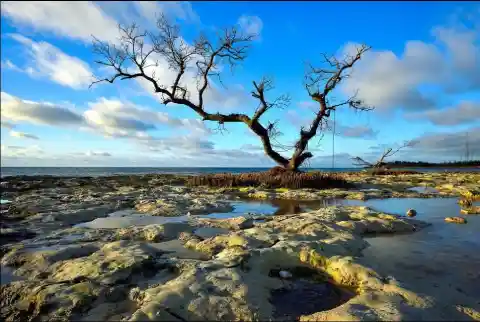
Devil's Lake State Park, Wisconsin
Devil's Lake State Park is located in the Baraboo Range in eastern Sauk County, just south of Baraboo, Wisconsin, and it is the biggest state park of Wisconsin. It covers an area of 9,217 acres, and it is known for its 500-foot-high quartzite bluffs along the 360-acre Devil's Lake. This lake was actually created due to the melting of a glacier during the last Ice Age, approximately 12,000 years ago.

The park also features a recreational space known as the Nature Center, which usually holds a couple of exhibitions that focus on the geology and natural history of the area. This space also contains many historical photographs that come from as far back as the 1800s, and they contain displays of examples of the flora and fauna that can be found in the park. Last but not least, public nature programs are offered in the summer, and on Saturday nights, evening programs are carried out in the park's Northern Lights Amphitheater.
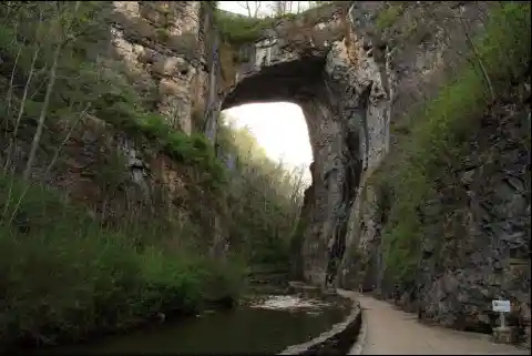
Natural Bridge State Park, Virginia
Once owned by Thomas Jefferson and listed on the National Register of Historic Places, the 215-foot tall Natural Bridge is a limestone gorge carved out by Cedar Creek. But the newest State Park of Virginia is more than just the bridge. Beautiful forests and open, rolling meadows cover the park, and several points offer amazing views of the James River Valley and its surrounding mountains.

Natural Bridge has several unique sandstone rock formations, including the Balanced Rock. This is a huge block of sandstone balanced on the edge of a cliff near the Natural Bridge. The Balanced Rock is located on Trail #2, not far above Hemlock Lodge. In the early days of the Park, it was called the Sphinx because it crudely resembles the Egyptian Sphinx if viewed from the correct angle.
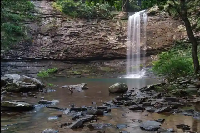
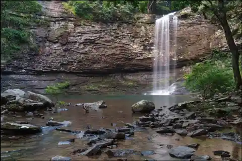
Cloudland Canyon State Park, Georgia
Cloudland Canyon is easily one the most scenic of Georgia’s State Parks. Stunning waterfalls, incredible long-range views, sheer canyon walls, and spectacular sunsets make the park one of Georgia's most popular hiking and camping destinations. Many miles of prime hiking and backpacking trails run through the park’s most remote, beautiful, and popular sights.
The park, previously known as Sitton Gulch or Trenton Gulf, was purchased in stages by the state of Georgia beginning in 1938. Under President Franklin D. Roosevelt, a project of Civilian Conservation Corps during the Great Depression built the park's first facilities and signs, which opened the following year. Today the park features a variety of campsites, cabins, hiking and recreational activities.
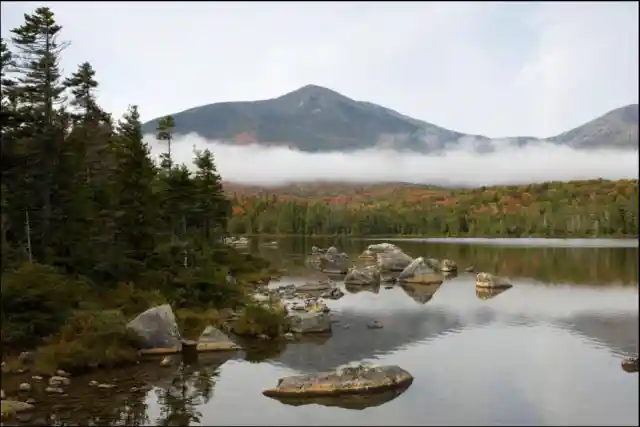
Baxter State Park, Maine
Baxter State Park is named after Percival P. Baxter, former governor of Maine. Apparently, he was obsessed with the idea of creating and protecting a wilderness haven for the people of Main to enjoy. This park harbors beautiful mountains and forests and is home to Mount Katahdin, Maine's highest peak.

Baxter is now a premier year-round destination for outdoor enthusiasts. It has a year-round staff of 22 people, but during summer, it rises to 61, including office administration and reservation personnel, field and law enforcement rangers and resource specialists. As you may imagine, the reason behind this is that during summer, the number of people that camp in the park is way higher: in fact, roughly 60,000 people visit the park just during the summer months.
Cape Henlopen State Park, Delaware
When the current lands of the state of Delaware were granted to William Penn sometime after 1682, Penn proclaimed that Cape Henlopen and its natural resources were to be for the common usage of the citizens of Lewes and Sussex County, thus establishing some of the nation's first "public lands."

As such, it has remained in the public domain ever since, playing a major role in local shipping and the nation's military history. The historic Henlopen Lighthouse no longer helps to guide vessels through the dangerous bay waters. However, the two stone "breakwaters" barriers off the Cape point, completed in 1869 and 1901, still form a safe harbor for boats during rough seas.
Eldorado Canyon State Park, Colorado
The Ute Native American tribes who lived in the mountains of Colorado and Utah frequented Eldorado Canyon, savoring the warm springs for health and spiritual renewal. By the mid-1800s, the Utes had lost most of eastern Colorado to settlers, so the Park remained mostly uninhabited. However, although they left the Eldorado Canyon before it became a State Park, a few arrowheads and artifacts remain in the area. In 1858, John Doudy was the first to homestead along South Boulder Creek.
Eldorado Canyon is noted for multi-pitch, traditionally protected sandstone rock climbs on cliffs, which are up to seven hundred feet high. Routes typically involve intricate and devious face climbing, interspersed with dihedrals and discontinuous, irregular cracks, where traditional removable gear placement skills are mandatory.
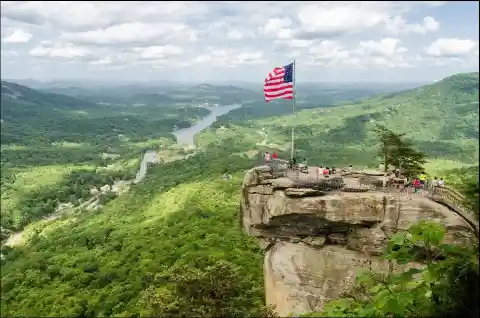
Chimney Rock State Park, North Carolina
Chimney Rock State Park was established on May 4, 2005. It covers an area of 6,807 acres, and it is notable for its overall biodiversity. It takes its name from the spectacular, one-mile-long series of steep rocky slopes, which also go by the name Chimney Rock. In the picture below, you can see Chimney Rock's most famous viewpoint.

The park also features a balancing rock named The Devil's Head, as well as a 404-foot waterfall named Hickory Nut Falls. Last but not least, a couple of years ago, the Weed Patch Mountain Bike Trail was inaugurated. This trail starts in Buffalo Creek Park and covers a 10-mile distance, taking you all the way to Chimney Rock, near the top of Shumont Mountain.
Ha Ha Tonka State Park, Missouri
Robert McClure Snyder, a businessman who came from humble beginnings, purchased Ha Ha Tonka Lake and Spring in 1904\. Immediately after, he began constructing roads and making extensive improvements in the area. Some decades later, this area was turned into a State Park, encompassing an area of 3,700 acres.
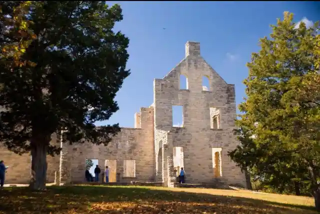
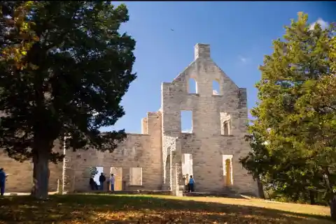
The park is a geologic wonderland with sinkholes, caves, a huge natural bridge, sheer bluffs, and Missouri’s 12th largest spring. The ruins of a 19th-century stone castle overlook these wonders and offer impressive views of the Lake of the Ozarks and Ha Ha Tonka Spring. A series of trails and boardwalks make it easy for visitors to experience all the park has to offer, from its historic castle and geologic wonders to its wooded areas and open rocky glades.
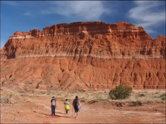
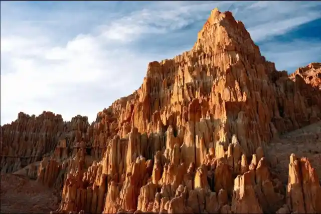
Palo Duro Canyon State Park, Texas
Palo Duro Canyon is the second largest canyon system in the United States. It is about 120 miles long, 20 miles wide, and up to 800 feet deep, and it extends from the towns of Canyon to Silverton. You can see the beautiful colors of its four geologic layers as you descend 500 feet to the floor of the canyon. These different shades can be appreciated in the picture below.
Due to its diverse habitats, Palo Duro Canyon is home to many types of wildlife. Two threatened species live here: the Palo Duro mouse and the Texas horned lizard. Other residents include wild turkeys, white-tailed and mule deer, coyotes, bobcats, roadrunners and many species of snakes and lizards. Moreover, the park is a great spot for bird watching: you will see Golden-fronted woodpeckers year-round, while Mississippi kites, Bullock’s orioles, and painted buntings come in the summer.
Niagara Falls State Park, New York
Geologically speaking, Niagara Falls is quite young. Some 12,000 years ago, the water plunged over the edge of the Niagara Escarpment, which is a steep slope that runs east to west from New York through Ontario, Michigan, Wisconsin, and Illinois. This escarpment is most famous for being the cliff over which the Niagara River drops off at Niagara Falls. This obviously explains why it was named the Niagara Escarpment.
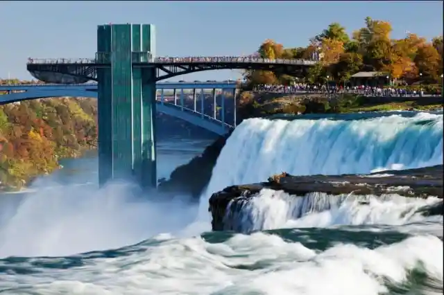
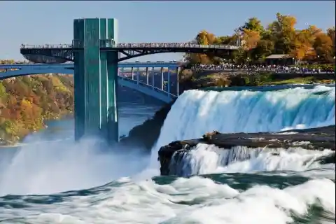
The Queen Victoria Niagara Falls Park, now known as Queen Victoria Park, was created in 1887\. Almost a century later, in 1963, the Niagara Reservation was declared a U.S. National Historic Landmark. It is definitely worth mentioning that this is one of the most visited Parks in all the US, receiving over 30 million tourists per year.
Bahia Honda State Park, Florida
The Bahia Honda Park is found on the island of Florida Keys. This uninhabited island features one of the deepest natural channels in the state of Florida. Besides, it is a great spot for snorkeling due to its reach marine life, including small reef fish, rays, barracuda, and even nurse sharks.
Between 1905 and 1912, a giant railway and several bridges were built across the park but were destroyed by the severe Labor Day Hurricane of 1935\. Later, the railroad bridge foundations were used to build the famous Overseas Highway. Part of the old Bahia Honda Bridge is accessible from the park and offers a panoramic view of the islands.
Cathedral Gorge State Park, Nevada
Nomadic Native Americans occupied this area as long ago as 10,000 BC. The Fremont, Anasazi and Southern Paiutes used the area for seasonal hunting of local games and gathering of edible plants. However, there is no evidence of any permanent settlements. After that, the town of Panaca was settled by Mormon pioneers in 1864. They were attracted to the area by abundant water resources, which allowed crops and livestock to flourish.

The park's different soil types permit various plant associations to grow. The "badland" topography below the eroded escarpment does not permit many plants to take root since the clay is constantly eroding away. Small sand dunes are held in place by many kinds of wildflowers and grasses, like dune primroses and Indian ricegrass.
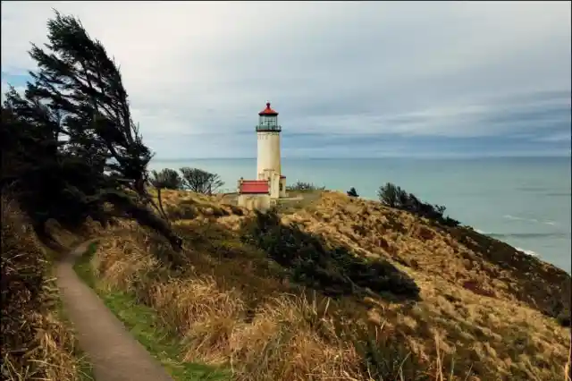
Cape Disappointment State Park, Washington
Located in a cove fronting the river, the beautiful Waikiki Beach offers a view of the Cape Disappointment Lighthouse and is an excellent storm-watching spot during the winter. This park is also home to Benson Beach, which extends two miles from the North Jetty to the rocky base of North Head, which makes a perfect place for beachcombing and kite-flying.

Hike through the old-growth forest or around freshwater lakes, saltwater marshes and ocean tidelands. Gape at the breathtaking views. Launch your boat from Baker Bay. Benson Beach is a popular clam-digging destination, and fishers love to set up on the North Jetty to catch salmon and crab. The beaches at Cape Disappointment also lure sand-castle builders and those who love to walk and explore.
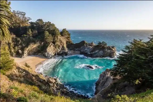
Pfeiffer Big Sur State Park, California
On the western slope of the Santa Lucia Mountains, the peaks of Pfeiffer Big Sur State Park tower high above the Big Sur River Gorge, where the Big Sur River enters this popular park. If you're a nature lover, you should walk along the river banks and among the redwoods, conifers, oaks, sycamores, cottonwoods, maples, alders and willows.

A moderately difficult 750-feet climb through a Redwood and Oak woodland will take you to a fork in the trail. Take the left fork to the Valley View Overlook, where you will be gifted with a tremendous view of the Big Sur River Valley, Pt. Sur and Andrew Molera State Park. Backtrack and take the right fork for a view of Pfeiffer Falls, a 60-foot waterfall. It sounds like a lot, but it's actually just a 2-mile trail, and if you go all the way through, you'll come across one of the most beautiful views you'll see.
Chugach State Park, Alaska
Chugach State Park covers 495,204 acres to the East of the Anchorage Bowl in south-central Alaska. Though primarily in the Municipality of Anchorage, the small portion of the park located north of the Eklutna Lake lies within the Matanuska-Susitna Borough. It is definitely worth mentioning that the most popular trailheads and more than 60 of the state’s most accessible glaciers are all found in the Chugach.
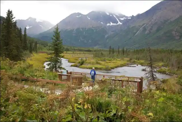
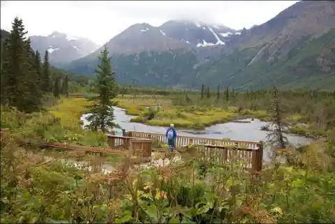
This park is home to Mt. Flattop, widely regarded as the most climbing mountain in Alaska. And while the trail to the summit is rocky and steep, there are a number of loop trails below, which are perfect for beginners or those with physical limitations. From the beginning of the trailhead all the way to the rocky top of Flattop, it’s approximately 3 miles and 1,500 feet of elevation gain.
Ecola State Park, Oregon
Wrapping around Tillamook Head, between Seaside and Cannon Beach, the Ecola State Park stretches along 9 miles of coastline and offers outstanding sightseeing and recreational opportunities combined with a storied past. From the moment you step foot into the park, you are rewarded with beautiful sights. The entrance road meanders through a lush Sitka spruce forest, eventually opening up to a grassy bluff offering breathtaking views of the Pacific Ocean.
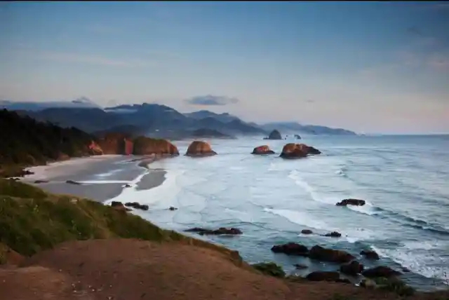
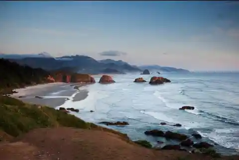
The Tillamook Head Trail extends six miles from the seaside to Cannon Beach. Tillamook Head is one of the highest points on the trail between Seaside and Indian Beach. It is named after Tillamook tribes, in whose ancestral territory the headland is located. Ecola’s trails offer cliffside viewpoints of secluded coves, forested promontories, and even a long-abandoned lighthouse.
Letchworth State Park, New York
Letchworth State Park was created by the stroke of the pen of New York State Governor Charles Evans Hughes in 1907\. The park is home to three large waterfalls on the Genesee River, which is surrounded by the multi-colored forest depicted in the picture below. A deep gorge is formed by the river, with rock walls rising up to 550 feet, which prompted the area's reputation as the "Grand Canyon of the East."
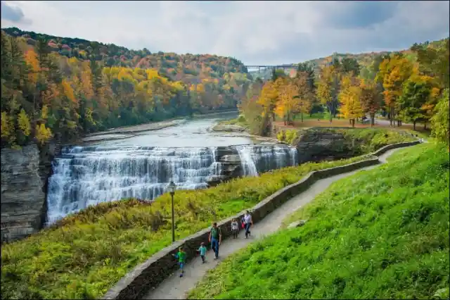

The three major waterfalls, known as the Upper, Middle, and Lower Falls, are located within Portage Canyon, the southern section of the park. If you are into educational trips, The Humphrey Nature Center offers year-round environmental education opportunities for school groups, scouts, youth organizations, and the general public.
Hunting Islands State Park, South Carolina
Beautiful Hunting Island is a bit of a contradiction. Located 15 miles east of Beaufort, the island is completely isolated, with just a handful of campsites and a main Visitor's Center. Despite this fact, the island is also the most visited state park in South Carolina and one of the most acclaimed beaches in the Southeast of the US.

Of all the lighthouses in South Carolina, the one located inside the park is the only one in the state that can be visited by the public. From the top of the lighthouse, every visitor can stand 130 feet above the ground to absorb the breathtaking and panoramic view of the Atlantic Coast and the surrounding maritime forest.
Waiʻānapanapa State Park, Hawaii
The remote town of Hana on Maui’s east side is known for being one of the last villages untouched by major development. To get there, most people take Hana Highway and embark on a breathtaking journey past lush bamboo forests, flowing waterfalls, and rugged coastline. Although it is only 52 miles from the central town of Kahului, the drive takes 2-4 hours due to Hana Road's 620 curves and 59 bridges.

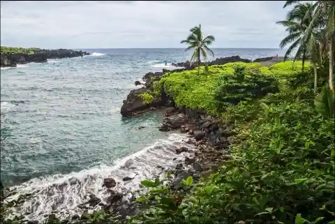
The jet black sands make a stunning contrast to the turquoise ocean and the abundance of tropical greenery, and altogether, they offer the perfect photo opportunity. However, don’t be tempted to swim here. The ocean floor drops off pretty close to shore, and surf tends to be rough since strong rip currents come through the bay without any warning. Lava flows have produced many other incredible natural rock formations such as islets, sea caves, cliffs, arches, a blowhole, and a lava tube, all of which can be seen at Waiʻānapanapa.
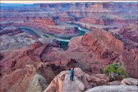
Dead Horse Point State Park, Utah
32 miles from Moab, Dead Horse Point State Park is one of Utah’s most spectacular state parks. The view from Dead Horse Point is one of the most photographed scenic vistas in the world. Towering 2,000 feet above the Colorado River, the overlook provides a breathtaking panorama of Canyonlands’ sculpted pinnacles and buttes.
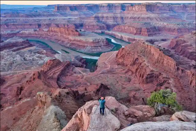
There are two trails in the park, and both are worth visiting. The East Rim Trail is 2 miles long and is the easiest of the two, and the views are pretty nice. The West Rim Trail is a one-way 3.5-mile-long trail, at least if you include the short detours to Shafer Canyon Overlook and Rim Overlook. The West Rim Trail starts at Dead Horse Point Overlook and ends at the Kayenta Campground.