Congaree National Park
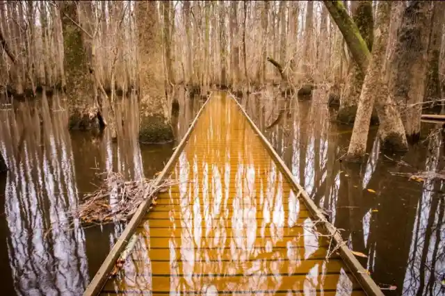
On the Congaree River, this park is the largest portion of the old-growth floodplain forest left in North America. Some of the trees are the tallest in the eastern United States. An elevated walkway called the Boardwalk Loop guides visitors through the swamp. The park received its official designation in 2003 as the culmination of a grassroots campaign that began in 1969\. The park preserves the largest tract of old-growth bottomland hardwood forest left in the United States.

Over two-thirds of the national monument was designated a wilderness area on October 24, 1988, and it became an Important Bird Area on July 26, 2001. Congress redesignated the monument Congaree National Park on November 10, 2003, dropping the misleading “swamp” from the name, and simultaneously expanded its authorized boundary by approximately 4,576 acres. As of December 31, 2011, approximately 26,021 acres of the park are in federal ownership.
Guadalupe Mountains National Park
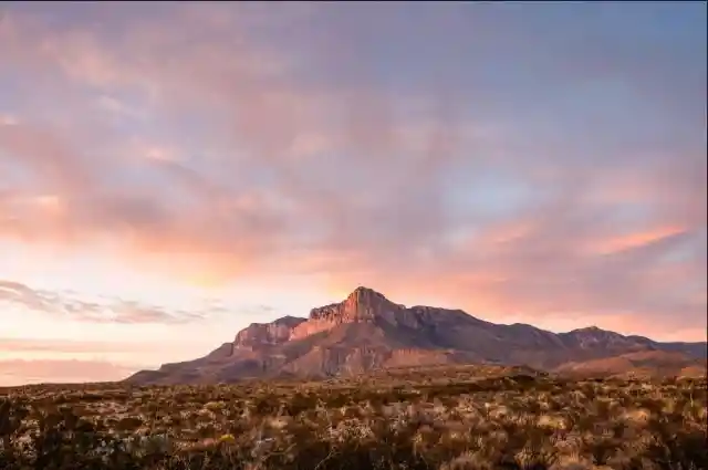
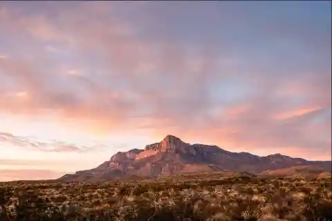
The mountain range includes Guadalupe Peak, which is the highest point in Texas at 8,749 feet, and El Capitan, which is used as a landmark by travelers on the route later followed by the Butterfield Overland Mail stagecoach line. The ruins of a stagecoach station stand near the Pine Springs visitor center. The restored Frijole Ranch contains a small museum of local history and is the trailhead for Smith Spring.
There are three major ecosystems contained within the mountain range. First of all, deserts exhibit salt flats on the western side of the National Park and creosote desert, with low elevations on the east covered with grassland, pinyon pine and junipers such as alligator juniper and one-seeded juniper. Secondly, canyon interiors such as McKittrick, Bear, and Pine Springs Canyon on the southeast end exhibit maple, ash, chinquapin oak, and other deciduous trees.
Cuyahoga National Park
This park along the Cuyahoga River has waterfalls, hills, trails, and exhibits on early rural living. The Ohio and Erie Canal Towpath Trail follows the Ohio and Erie Canal, where mules towed canal boats. The park has numerous historic homes, bridges, and structures and also offers a scenic train ride. The 32,572-acre park is administered by the National Park Service, but within its boundaries are areas independently managed as city parks or private businesses.


Cuyahoga Valley features natural, man-made, and private attractions, which is unusual for an American national park. The park includes compatible-use sites not owned by the federal government, such as regional parks of the Cleveland Metroparks and Summit Metro Parks systems. The natural areas include forests, rolling hills, narrow ravines, wetlands, rivers, and waterfalls. About 100 waterfalls are located in the Cuyahoga Valley, with the most popular being the 65-foot tall Brandywine Falls (the tallest waterfall in the park and the tallest in Northeast Ohio).
Carlsbad Caverns National Park
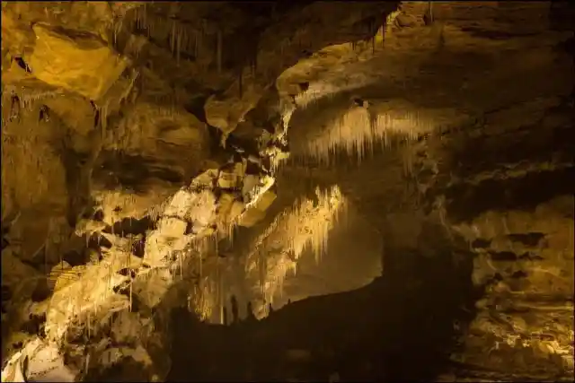
Carlsbad Caverns has 117 caves, the longest of which is over 120 miles long. The Big Room is almost 4,000 feet long, and the caves are home to over 400,000 Mexican free-tailed bats and sixteen other species. Above ground are the Chihuahuan Desert and Rattlesnake Springs. The park entrance is located on U.S. Highway 62/180, approximately 18 miles southwest of Carlsbad, New Mexico. Carlsbad Caverns National Park participates in the Junior Ranger Program.

Carlsbad Caverns had an average annual visitation of about 410,000 in the period from 2007 to 2016\. Peak visitation typically occurs on the weekends following Memorial Day and the Fourth of July. Free admittance for self-guided tours is often granted on holidays such as Martin Luther King, Jr. weekend, National Park Week, and Veterans Day weekend. Camping is permitted in the backcountry of the park, but a permit is required from the visitor center.
Shenandoah National Park
Shenandoah National Park lies along the Blue Ridge Mountains in north-central Virginia. These mountains form a distinct highland rising to elevations above 4,000 feet. Local topographic relief between the Blue Ridge Mountains and Shenandoah Valley exceeds 3,000 feet at some locations. The crest of the range divides the Shenandoah River drainage basin, part of the Potomac River drainage, on the west side, from the James and Rappahannock River drainage basins on the east side.

The climate of the park, and in turn also its flora and fauna, is largely typical for mountainous regions of the eastern Mid-Atlantic woodland, and indeed a large portion of common species are typical of ecosystems at lower altitudes as well. On southwestern faces of some of the southernmost hillsides, pine predominates, and there is also the occasional prickly pear cactus, which grows naturally. In contrast, some of the northeastern aspects are most likely to have small but dense stands of moisture-loving hemlocks and mosses in abundance.
Virgin Islands National Park
In 1956, Laurance Rockefeller’s Jackson Hole Preserve donated its extensive lands on the island to the National Park Service, under the condition that the lands had to be protected from future development. The remaining portion, the Caneel Bay Resort, operates on a lease arrangement with the NPS, which owns the underlying land. The boundaries of the Virgin Islands National Park include 75% of the island, but various in-holdings within the park boundary reduce the parklands to 60% of the island acreage. Much of the island’s waters, coral reefs, and shoreline have been protected by being included in the national park.


Virgin Islands National Park has a tropical savannah climate. The average rainfall per year is 55 inches. In the winter, trade winds blow from 20 km/h to 39 km/h. The average temperature for the park is 79°F. The park experiences very little temperature variation between summer and winter, while the sea is warm year-round. The main tourist season is from December to April, which are the driest months. During the remaining months (i.e., the Atlantic hurricane season), prices for accommodations are reduced considerably. Camping and rustic lodging are available in the park from November through August at Cinnamon Bay Campground.
Mount Rainer National Park
Mount Rainier, an active stratovolcano, is the most prominent peak in the Cascades and is covered by 26 named glaciers, including Carbon Glacier and Emmons Glacier, the largest in the contiguous United States. The mountain is popular for climbing, and more than half of the park is covered by subalpine and alpine forests and meadows seasonally in bloom with wildflowers.
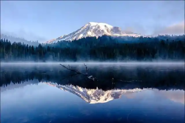
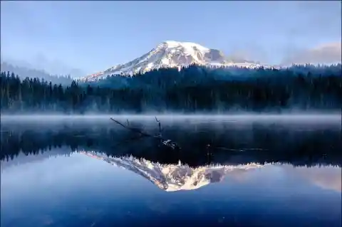
Paradise is the name of an area at approximately 5,400 feet on the south slope of Mount Rainier in the national park. Paradise is the most popular destination for visitors to Mount Rainier National Park. 62% of the over 1.3 million people who visited the park in 2000 went to Paradise. It is located near the subalpine valley of the Paradise River. It is the location of the historic Paradise Inn (built in 1916), Paradise Guide House (built in 1920) and Henry M. Jackson Visitor Center (built in 1966).
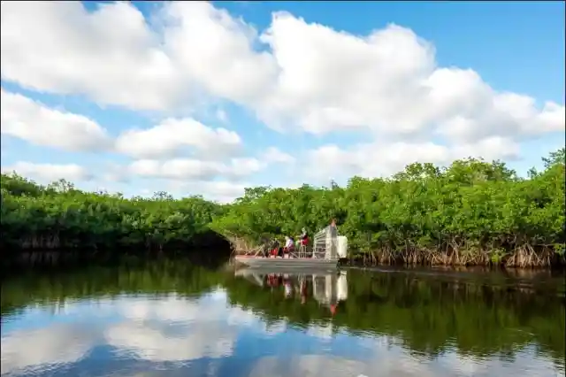
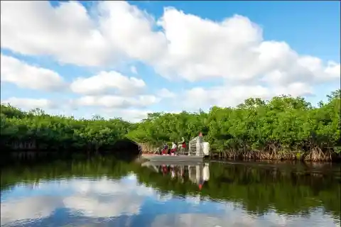
Biscayne National Park
Biscayne National Park is a national park in southern Florida, south of Miami. The park preserves Biscayne Bay and its offshore barrier reefs. Ninety-five percent of the park is water, and the shore of the bay is the location of an extensive mangrove forest. The park covers 172,971 acres and includes Elliott Key, the park’s largest island and first of the true Florida Keys, formed from fossilized coral reefs. The islands farther north in the park are transitional islands of coral and sand.


The open waters are inhabited by fishes, mollusks and crustaceans living on seagrasses or who prey on each other. The shallowness of the lagoon makes it a suitable habitat for diving birds such as Anhinga, cormorants and diving ducks. The bay also provides a habitat for juvenile sea animals that have left the shelter of the mangrove belts. Manatees frequent the quiet waters of the bay. The bay has a year-round population of double-crested cormorants. Winter residents include northern gannets, American white pelicans and common loons.
Petrified Forest National Park
Named for its large deposits of petrified wood, the fee area of the park covers about 230 square miles, encompassing semi-desert shrub steppe as well as highly eroded and colorful badlands. This portion of the Chinle Formation has a large concentration of 225-million-year-old petrified wood. The surrounding Painted Desert features eroded cliffs of red-hued volcanic rock called bentonite. Dinosaur fossils and over 350 Native American sites are also protected in this park.
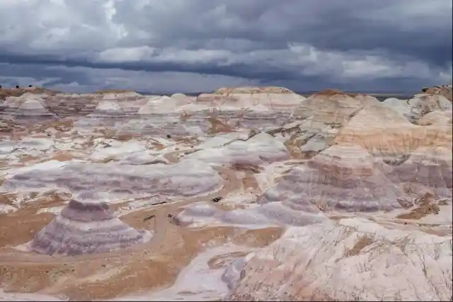
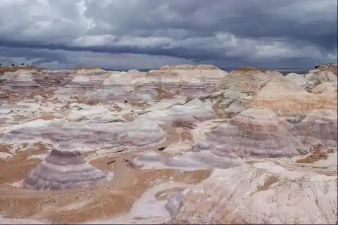
The Petrified Forest is known for its fossils, especially fallen trees that lived in the Late Triassic Epoch, about 225 million years ago. The sediments containing the fossil logs are part of the widespread and colorful Chinle Formation, from which the Painted Desert gets its name. Beginning about 60 million years ago, the Colorado Plateau, of which the park is part, was pushed upward by tectonic forces and exposed to increased erosion. All of the park’s rock layers above the Chinle, except geologically recent ones found in parts of the park, have been removed by wind and water.
Mammoth Cave National Park
With more than 400 miles of passageways explored, Mammoth Cave is the world’s longest-known cave system. Subterranean wildlife includes eight bat species, Kentucky cave shrimp, Northern cavefish, and cave salamanders. Above ground, the park provides recreation on the Green River, 70 miles of hiking trails, and plenty of sinkholes and springs.

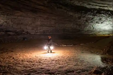
The National Park Service offers several cave tours to visitors. Some notable features of the cave, such as Grand Avenue, Frozen Niagara, and Fat Man’s Misery, can be seen on lighted tours ranging from one to six hours in length. Two tours, lit only by visitor-carried paraffin lamps, are popular alternatives to the electric-lit routes. Several “wild” tours venture away from the developed parts of the cave into muddy crawls and dusty tunnels. The Echo River Tour, one of the cave’s most famous attractions, used to take visitors on a boat ride along an underground river. The tour was discontinued for logistic and environmental reasons in the early 1990s.
Dry Tortugas National Park
The Dry Tortugas is a small archipelago of coral islands about 70 miles west of Key West, Florida. They represent the westernmost extent of the Florida Keys, though several reefs and submarine banks continue westward outside the park, beyond the Tortugas. Dry Tortugas National Park is a national park about 68 miles west of Key West in the Gulf of Mexico. The park preserves Fort Jefferson and the seven Dry Tortugas islands, the westernmost and most isolated of the Florida Keys.
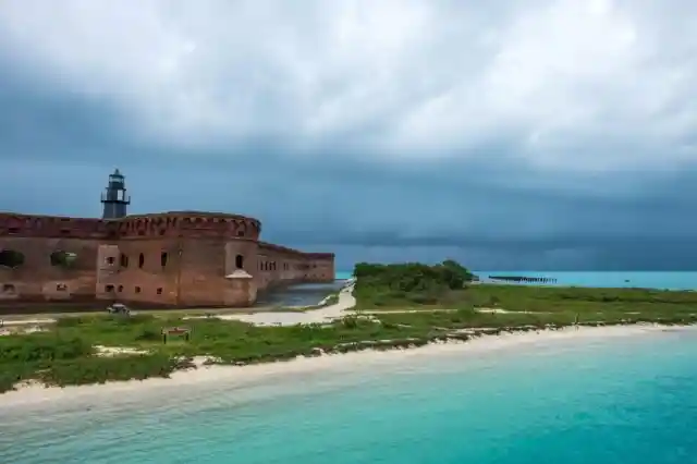
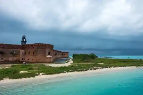
Birdwatching activity peaks each spring (usually April) when dozens of migratory bird species can pass through the park in a single day. Many birds land inside the parade grounds of Fort Jefferson, where they are often observed at close range. Common migratory warblers include the northern parula, American redstart, prairie warbler, hooded warbler, palm warbler, black-and-white warbler, common yellowthroat, yellow-rumped warbler, ovenbird, northern waterthrush, black-throated blue warbler, blackpoll warbler, and Cape May warbler, with more than 20 additional warbler species have shown up at least once.
Great Sand Dunes National Park
The tallest dunes in North America, up to 750 feet tall, were formed by deposits of the ancient Rio Grande in the San Luis Valley. Abutting a variety of grasslands, shrublands, and wetlands, the park also has alpine lakes, six 13,000-foot mountains, and old-growth forests. The dunes cover an area of about 30 square miles and are estimated to contain over 1.2 cubic miles of sand.
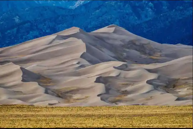

The four primary components of the Great Sand Dunes system are the mountain watershed, the dune field, the sand sheet, and the sabkha. The mountain watershed receives heavy snow and rain, which feeds creeks that flow down from alpine tundra and lakes, through subalpine and montane woodlands, and finally around the main dune field. Sand that has blown from the valley floor is captured in streams and carried back toward the valley. As creeks disappear into the valley floor, the sand is picked up and carried to the dune field once again.
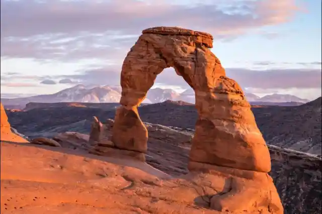
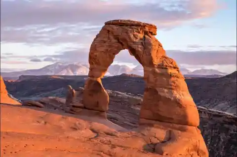
Arches National Park
This site features more than 2,000 natural sandstone arches, with some of the most popular arches in the park being Delicate Arch, Landscape Arch and Double Arch. Millions of years of erosion have created these structures located in a desert climate where the arid ground has life-sustaining biological soil crusts and potholes that serve as natural water-collecting basins.
The Arches area was first brought to the attention of the National Park Service by Frank A. Wadleigh, passenger traffic manager of the Denver and Rio Grande Western Railroad. Wadleigh, accompanied by railroad photographer George L. Beam, visited the area in September 1923 at the invitation of Alexander Ringhoffer, a Hungarian-born prospector living in Salt Valley. Ringhoffer had written to the railroad in an effort to interest them in the tourist potential of a scenic area he had discovered the previous year with his two sons and a son-in-law, which he called the “Devil’s Garden“.
North Cascades National Park
This complex includes two geographically distinct units of the national park, as well as Ross Lake and Lake Chelan National Recreation Areas. The highly glaciated mountains are spectacular examples of Cascade geology. Popular hiking and climbing areas include Cascade Pass, Mount Shuksan, Mount Triumph, and Eldorado Peak. Heavy snows and a high risk of avalanches due to the steep terrain, especially on the western slopes, severely limit visitation in the winter. Most access to the park is from State Route 20, which follows the Skagit River, though even this road is closed for months at a time in the winter.

North Cascades National Park is managed by the National Park Service, and the park headquarters is in Sedro-Woolley, Washington. The park consists of a northern and a southern district or unit. These are separated by Ross Lake National Recreation Area. The southeast boundary of the southern district abuts Lake Chelan National Recreation Area; the park and two recreation areas are managed as the North Cascades National Park Complex. Most of the park complex was designated as the Stephen Mather Wilderness, preventing further human-induced alterations to 93 percent of the park.
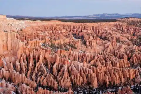
Bryce Canyon National Park
The major feature of the park is Bryce Canyon, which despite its name, is not a canyon but a collection of giant natural amphitheaters along the eastern side of the Paunsaugunt Plateau. Bryce is distinctive due to geological structures called hoodoos, formed by frost weathering and stream erosion of the river and lake bed sedimentary rocks. The red, orange and white colors of the rocks provide spectacular views for park visitors.

Most park visitors sightsee using the scenic drive, which provides access to 13 viewpoints over the amphitheaters. Bryce Canyon has eight marked and maintained hiking trails that can be hiked in less than a day: Mossy Cave, Rim Trail, Bristlecone Loop, and Queens Garden are easy to moderate hikes. Navajo Loop and Tower Bridge are moderate hikes. Fairyland Loop and Peekaboo Loop are strenuous hikes. Several of these trails intersect, allowing hikers to combine routes for more challenging hikes.
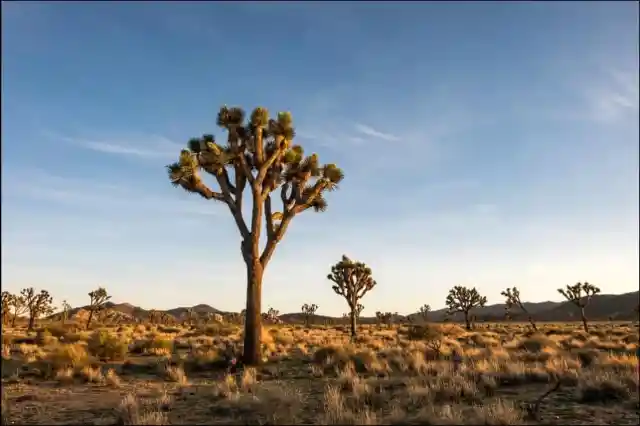
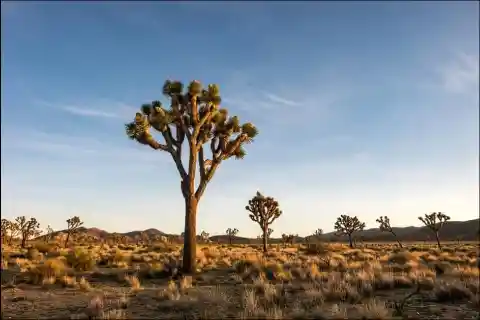
Joshua Tree National Park
Covering large areas of the Colorado and Mojave Deserts and the Little San Bernardino Mountains, this desert landscape is populated by vast stands of Joshua trees. Large changes in elevation reveal various contrasting environments, including bleached sand dunes, dry lakes, rugged mountains, and maze-like clusters of monzogranite monoliths.
The park is popular with rock climbers and was originally a winter practice area while Yosemite Valley and other parts of the Sierra Nevada were snowbound but later became an area of interest in its own right. There are thousands of named climbing routes at all levels of difficulty. The routes are typically short, the rocks being rarely more than 230 ft in height, but access is usually a short, easy walk through the desert, and it is possible to do a number of interesting climbs in a single day.
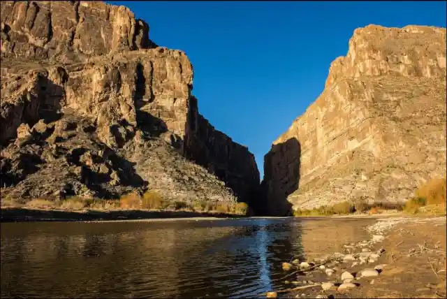
Big Bend National Park
Named for the prominent bend in the Rio Grande along the U.S.–Mexico border, this park encompasses a large and remote part of the Chihuahuan Desert. Its main attraction is backcountry recreation in the arid Chisos Mountains and in canyons along the river. A wide variety of Cretaceous and Tertiary fossils, as well as cultural artifacts of Native Americans, also exist within its borders.

Big Bend’s primary attraction is its hiking and backpacking trails. Particularly notable among these are the Chimneys Trail, which visits a rock formation in the desert; the Marufo Vega trail, a loop trail that passes through scenic canyons on the way to and from the Rio Grande; the South Rim trail which circles the high mountains of the Chisos; and the Outer Mountain Loop trail in the Chisos, which incorporates parts of the South Rim loop, descends into the desert along the Dodson Trail, and then returns to the Chisos Basin, completing a 30-mile loop.
Everglades National Park
The Everglades is the largest tropical wilderness in the United States. This mangrove and tropical rainforest ecosystem and marine estuary is home to 36 protected species, including the Florida panther, American crocodile, and West Indian manatee. Some areas have been drained and developed; restoration projects aim to restore the ecology
The park is the largest tropical wilderness in the United States and the largest wilderness of any kind east of the Mississippi River. An average of one million people visits the park each year. Everglades is the third-largest national park in the contiguous United States after Death Valley and Yellowstone. UNESCO declared the Everglades & Dry Tortugas Biosphere Reserve in 1976, and listed the park as a World Heritage Site in 1979, while the Ramsar Convention included the park on its list of Wetlands of International Importance in 1987\. Everglades is one of only three locations in the world to appear on all three lists.
Grand Teton National Park
Grand Teton is the tallest mountain in the Teton Range. The park’s historic Jackson Hole and reflective piedmont lakes teem with endemic wildlife, with a backdrop of craggy mountains that rise abruptly from the sage-covered valley. Grand Teton National Park is only 10 miles south of Yellowstone National Park, to which it is connected by the Memorial Parkway. Along with surrounding national forests, these three protected areas constitute the almost 18,000,000-acre Greater Yellowstone Ecosystem, one of the world’s largest intact mid-latitude temperate ecosystems.
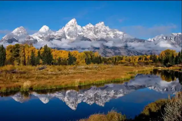
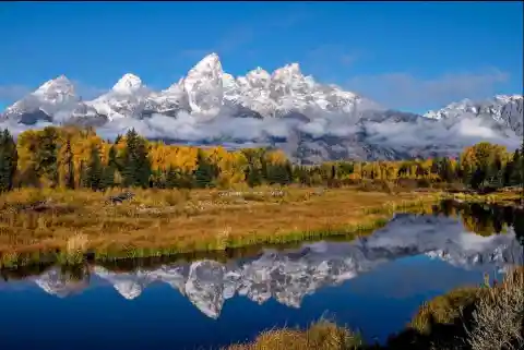
The youngest mountain range in the Rocky Mountains, the Teton Range, began forming between 6 and 9 million years ago. It runs roughly north to south and rises from the floor of Jackson Hole without any foothills along a 40-mile-long by 7- to 9-mile-wide active fault-block mountain front. The range tilts westward, rising abruptly above Jackson Hole valley, which lies to the east but more gradually into Teton Valley to the west. A series of earthquakes along the Teton Fault slowly displaced the western side of the fault upward and the eastern side of the fault downward at an average of 1 foot of displacement every 300–400 years.
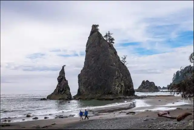
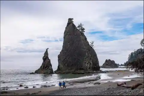
Olympic National Park
Situated on the Olympic Peninsula, this park includes a wide range of ecosystems from Pacific shoreline to temperate rainforests to the alpine slopes of the Olympic Mountains, the tallest of which is Mount Olympus. The Hoh Rainforest and Quinault Rainforest are the wettest areas in the contiguous United States, with the Hoh receiving an average of almost 12 ft (3.7 m) of rain every year.
Within the center of Olympic National Park rise the Olympic Mountains, whose sides and ridgelines are topped with massive, ancient glaciers. The mountains themselves are products of accretionary wedge uplifting related to the Juan De Fuca Plate subduction zone. The geologic composition is a curious mélange of basaltic and oceanic sedimentary rock. The western half of the range is dominated by the peak of Mount Olympus, which rises to 7,965 feet. Mount Olympus receives a large amount of snow, and consequently, it has the greatest glaciation of any non-volcanic peak in the contiguous United States outside of the North Cascades.
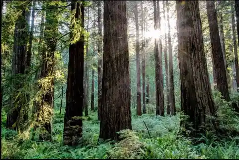
Redwood National Park
The Redwood National and State Parks (RNSP) are a complex of several state and national parks located in the United States, along with the coast of northern California. Comprising Redwood National Park and California’s Del Norte Coast, Jedediah Smith, and Prairie Creek Redwoods State Parks, the combined RNSP contain 139,000 acres and feature old-growth temperate rainforests. The northern portion of that area, originally inhabited by Native Americans, attracted many lumbermen and others turned gold miners when a minor gold rush brought them to the region.

The United Nations designated Redwood National and State Parks a World Heritage Site on September 5, 1980\. The evaluation committee noted 50 prehistoric archaeological sites spanning 4,500 years. It also cited ongoing research in the park by Humboldt State University researchers, among others. The park is part of a much larger region designated the _California Coast Ranges_ International Biosphere Reserve on June 30, 1983\. The California Coast Ranges biosphere is overseen by the University of California Natural Reserve System.
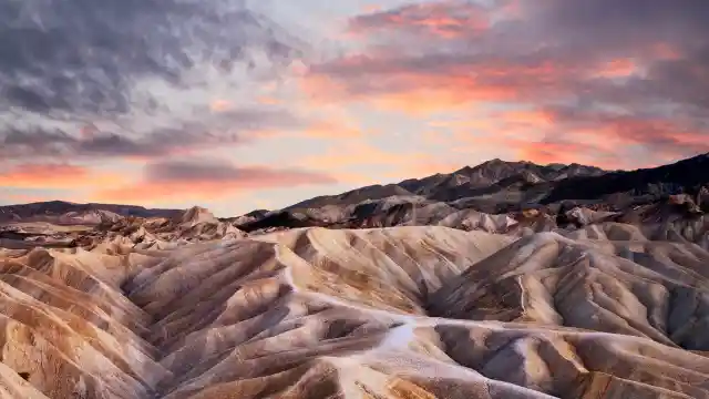
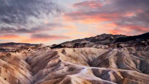
Death Valley National Park
Death Valley is the hottest, lowest, and driest place in the United States, with daytime temperatures that have exceeded 54°C. The park protects Badwater Basin and its vast salt flats located at the lowest elevation in North America −86 m. The park also protects canyons, badlands, sand dunes, mountain ranges, historic mines, springs, and more than 1000 species of plants that grow in this geologic graben.
A series of Native American groups inhabited the area from as early as 7000 BC, most recently the Timbisha around 1000 AD, who migrated between winter camps in the valleys and summer grounds in the mountains. A group of European-Americans, trapped in the valley in 1849 while looking for a shortcut to the goldfields of California, gave the valley its name, even though only one of their group died there. Several short-lived boom towns sprang up during the late 19th and early 20th centuries to mine gold and silver.
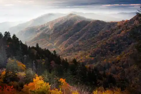
Great Smoky Mountains National Park
The Great Smoky Mountains National Park is the most visited national park in the system and home to approximately 1,500 black bears and more than 240 species of birds. It is a UNESCO World Heritage Site that straddles the ridgeline of the Great Smoky Mountains, part of the Blue Ridge Mountains, which are a division of the larger Appalachian Mountain chain. The border between Tennessee and North Carolina runs northeast to southwest through the centerline of the park.

The majority of rocks in the Great Smoky Mountains National Park are Late Precambrian rocks that are part of the Ocoee Supergroup. This group consists of metamorphosed sandstones, phyllites, schists, and slate. Early Precambrian rocks are not only the oldest rocks in the park but also the dominant rock type in sites such as the Raven Fork Valley and upper Tuckasegee River between Cherokee and Bryson City. They primarily consist of metamorphic gneiss, granite, and schist. Cambrian sedimentary rocks can be found at the bottom of the Foothills to the northwest and in limestone coves such as Cades Cove.
Grand Canyon National Park
The rim-to-rim hike in the Grand Canyon is one of the favorites hikes in the world for most adventurers. Nonetheless, several hikers will hike down the shorter but steeper South Kaibab Trail and then back up the longer but less steep, Bright Angel Trail. The park’s central feature is the Grand Canyon, a gorge of the Colorado River, which is often considered one of the Wonders of the World.
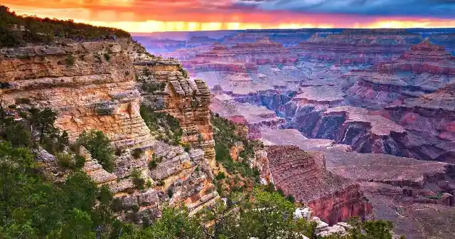

The Grand Canyon, including its extensive system of tributary canyons, is valued for its combination of size, depth, and exposed layers of colorful rocks dating back to Precambrian times. The canyon itself was created by the incision of the Colorado River and its tributaries after the Colorado Plateau was uplifted, causing the Colorado River system to develop along its present path. The primary public areas of the park are the South and North Rims and adjacent areas of the canyon itself. The rest of the park is extremely rugged and remote, although many places are accessible by pack trail and backcountry roads.
Crater Lake National Park
Crater Lake National Park is a national park located in southern Oregon. Established in 1902, Crater Lake is the fifth-oldest national park in the United States and the only national park in Oregon. The park encompasses the caldera of Crater Lake, a remnant of a destroyed volcano, Mount Mazama, and the surrounding hills and forests. The lake is 1,949 feet deep at its deepest point, which makes it the deepest lake in the United States, the second-deepest in North America and the ninth deepest in the world.
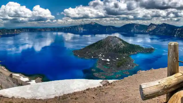
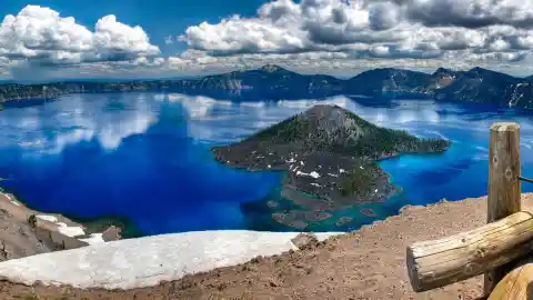
Volcanic activity in this area is fed by subduction off the coast of Oregon as the Juan de Fuca Plate slips below the North American Plate. Heat and compression generated by this movement created a mountain chain topped by a series of volcanoes, which together are called the Cascade Range. The large volcanoes in the range are called the High Cascades. However, there are many other volcanoes in the range as well, most of which are much smaller.
Sequoia National Park
The park is notable for its giant sequoia trees, including the General Sherman tree, the largest tree on Earth. The General Sherman tree grows in the Giant Forest, which contains five of the ten largest trees in the world. The Giant Forest is connected by the Generals Highway to Kings Canyon National Park’s General Grant Grove, home of the General Grant tree, among other giant sequoias.
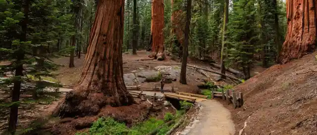
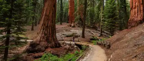
The park’s giant sequoia forests are part of 202,430 acres of old-growth forests shared by Sequoia and Kings Canyon National Parks. The parks preserve a landscape that still resembles the southern Sierra Nevada before Euro-American settlement. Sequoia National Park contains a significant portion of the Sierra Nevada. The park’s mountainous landscape includes the tallest mountain in the contiguous United States, Mount Whitney, which rises to 14,505 feet above sea level.
Yosemite National Park
Yosemite National Park is a national park located in the western Sierra Nevada of Central California, bounded on the southeast by Sierra National Forest and on the northwest by Stanislaus National Forest. The park is managed by the National Park Service and covers an area of 747,956 acres and sits in four counties: centered in Tuolumne and Mariposa, extending north and east to Mono and south to Madera County. Designated a World Heritage site in 1984, Yosemite is internationally recognized for its granite cliffs, waterfalls, clear streams, giant sequoia groves, lakes, mountains, meadows, glaciers, and biological diversity

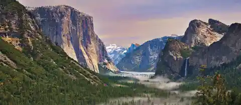
The geology of the Yosemite area is characterized by granite rocks and remnants of older rock. About 10 million years ago, the Sierra Nevada was uplifted and then tilted to form its relatively gentle western slopes and the more dramatic eastern slopes. The uplift increased the steepness of stream and river beds, resulting in the formation of deep, narrow canyons. About one million years ago, snow and ice accumulated, forming glaciers at the higher alpine meadows that moved down the river valleys. Ice thickness in Yosemite Valley may have reached 4,000 feet during the early glacial episode.
Acadia National Park
Acadia National Park is a national park located in the state of Maine, southwest of Bar Harbor. The park preserves about half of Mount Desert Island, many adjacent smaller islands, and part of the Schoodic Peninsula on the coast of Maine. Acadia was initially designated Sieur de Monts National Monument by proclamation of President Woodrow Wilson in 1916. Bass Harbor Lighthouse is the quintessential view in Acadia National Park. If you are looking for iconic Acadia, this is it. To get this shot, sunset is best, and be sure to use a tripod and a wide-angle lens
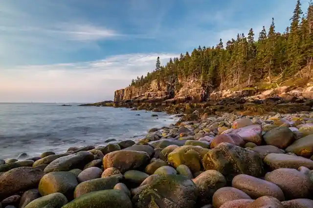
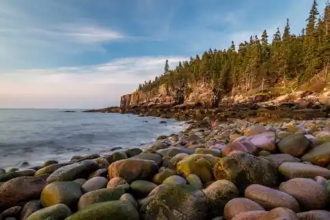
The park includes mountains, an ocean coastline, coniferous and deciduous woodlands, lakes, ponds, and wetlands encompassing a total of 49,075 acres. Key sites on Mount Desert Island include the Cadillac Mountain —the tallest mountain on the eastern coastline and one of the first places in the United States where one can watch the sunrise— a rocky coast featuring Thunder Hole where waves crash loudly into a crevasse around high tides, a sandy swimming beach called Sand Beach, and numerous lakes and ponds.
Yellowstone National Park
Situated on the Yellowstone Caldera, the park has an expansive network of geothermal areas, including boiling mud pots, vividly colored hot springs such as Grand Prismatic Spring, and regularly erupting geysers, the best-known being Old Faithful. The Great Fountain Geyser is one of the most beautiful places in the park to photograph at sunset, and it is one of the few that you can drive right up to, making it an easy place to catch the late afternoon light after a busy day of viewing every other landmark in the park.
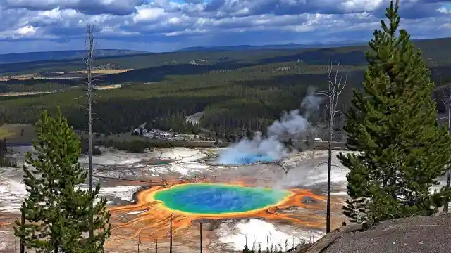
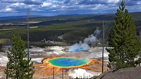
The yellow-hued Grand Canyon of the Yellowstone River contains several high waterfalls, and four mountain ranges traverse the park. More than 60 mammal species, including gray wolves, grizzly bears, black bears, lynxes, bison, and elk, make this park one of the best wildlife viewing spots in the country.
Zion National Park
One of the most photographed views in Zion National Park, and perhaps all of the parks, is the view of the Watchman from the Canyon Junction Bridge. Although it has been shot endless times, and you are sure to be shoulder to shoulder with other photographers during sunset, it is still something everyone must do when visiting the park.
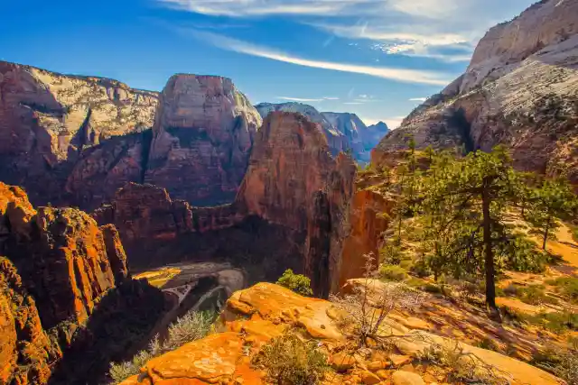
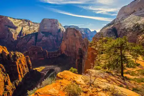
Located at the junction of the Colorado Plateau, Great Basin, and the Mojave Desert, this park contains sandstone features such as mesas, rock towers, and canyons, including the Virgin River Narrows. The various sandstone formations and the forks of the Virgin River create a wilderness divided into four ecosystems: desert, riparian, woodland, and coniferous forest.